The Pilbara
The first thing most Australians will know about the Pilbara is the mining and in particular the infamous Wittenoom asbestos mining operation of years past. Others might know it for the Hamersley Ranges, the mountain range that runs through the region and over many eons has created almost unlimited iron ore as well as some spectacular mountains. The Pilbara is also known for two towns with interesting names – Tom Price and Marble Bar. But the Pilbara has two outstanding national parks and even though the region plays second fiddle to the much larger and more famous Kimberley region to the north it is still a must see place.
We drove down the interestingly named Bore Line Road, a wide soft dirt track through beautiful country of red rock formations and endless plains of pincushion spinifex, or spikey grass as Julie calls it. This is mining country and we saw many remnants of old mines in the region on the way into the small town of Marble Bar, one of the original mining communities.
Today Marble Bar has an official population of 360 although one might wonder where they are all hiding. Prospectors have found many minerals in the nearby mountains over the years, including gold which was mined unprofitably nearby until the 1950’s. We visited the old gold mine and dropped into the famous Iron Clad Hotel dating back to 1880. Imagine the stories it could tell!
But Marble Bar’s more recent claim to fame is its reputation as the hottest town in Australia. It regularly records temperatures that are the highest in the nation, including an amazing run in 1923/24 when it recorded 160 days in a row over 100 degrees Fahrenheit (37.8 degrees C). The gods were friendly to us on our visit as it was only 33.9 degrees.
Three hundred kilometres down the corrugated road is the town of Newman, the modern example of a mining town, built in the late 1960’s to support BHP Billiton’s massive iron ore business. Newman was colourless and bland but at the same time neat and tidy, a company town through and through as evident from the company vehicles filling every car park, the signs, the buildings and all the people in their bright yellow or orange hiviz shirts.
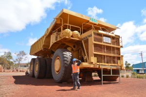
We did a fascinating mine tour of their iron ore operation, the largest single open cut mine in the world, turning what was called Whaleback Mountain into an inverted mountain with a cut 5.5 km long and up to 600 metres deep. We drove to the top of a hill to look down on this vast hole in the ground and watched huge dump trucks be loaded with rubble from recent blasts and take it away for processing and eventual transport by trains to the coast for export. The trains themselves consist of up to 300 cars and depart 12 times a day to the port. The whole setup almost defied belief in its size and scope, a very impressive operation.

Size does matter - a quick pose in front of one of the retired 'little' dumpers at the iron ore mine
A short distance away is Kanjini National Park which claims, amongst other features, to have ‘the best lookout in Australia’. And indeed it’s a legitimate claim as you can stand in one place and see four deep gorges all flow in together, a geologic fluke that had a serious wow factor.
We had to get down inside these things to get a better view. First we followed the track down into Hancock Gorge, a narrow canyon with high vertical red walls and water running through it, and as it got more narrow we were forced to cling to the walls like spiders to stay above the deep pools, at other times we had no choice but to wade through shallower water, following the stream down narrow chutes as far as we were allowed without climbing gear. This was seriously great fun.
Not satisfied with just one gorge, we also went down Weano Gorge, only to find a similar scenario with similar challenges, narrow gaps we squeezed through, wading through cold water and marvelling at the beautiful power of water on sandstone. At one stage the wading through waist deep water got the best of Julie, she slipped off a rock and fell in. After a quick surprised look crossed her face she playfully swam through the narrow gap while I bravely and barely clung to the wall. Eventually we made the final deep pool of this adventure and had to return the way we came – in Julie’s case, swimming.
The main track to our next destination, Millstream Chichester National Park, was up a rail line road owned by Rio Tinto, another mining giant. This region is clearly managed and controlled by the mining companies, even to the extent that roads between national parks require a permit from the company. We camped that night in the national park on the Fortescue River camp, again not allowed to have fires and really starting to feel the cold at night as we drop latitudes.
The next day we drove to the upper part of this large park and walked four kilometres along the old Cameleers Trail which was built in the 1860’s to help the pioneering sheep stations move their wool to the coast for shipment to town markets. The workmanship of blasting rocks and building this track for their camels over 150 years ago was astounding, so much so that the trail and their handwork still largely exists today. We finished the hot walk by a beautiful cool swim in the nearby Python Pool, a fitting way to end our visit to this park.
That night, which was day 76 on our journey around Australia, we had a delightful bush camp on the Cane River, finally enjoying a warm fire and a good barbeque. But the days have been getting windy and the temperature has been dropping. When we woke up that morning on the river it was only 9 degrees. Our days of 35 degree heat, sweat and red dust may be over….except for the red dust.
The Pilbara has been a fantastic experience, a great eye opener in more ways than one for both of us. It has given us a fascinating look at local history, a good insight to the enormous mining industry that the entire nation has benefited from, beautiful geologic formations and great gorges for our own little adventures. We’re going to head back to the coast for more sand and surf but we’ve marked the Pilbara for a future return trip.


